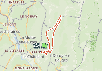
![](/images/other/stat-length.png)
![Trail Walking Le Châtelard - Mont Julioz _ Bauges : circuit à partir des Garins - Photo](https://media.geolcdn.com/t/1900/400/ext.pjpeg?maxdim=2&url=https%3A%2F%2Fstatic1.geolcdn.com%2Fsiteimages%2Fupload%2Ffiles%2F1553511878bg_sport_marche.png)
Mont Julioz _ Bauges : circuit à partir des Garins
ranchoup
User
![Length](/images/other/stat-length.png)
![Max alt](https://static1.geolcdn.com/siteimages/upload/files/1508320355ic_sort_altitude_max_24dp.png)
![Uphill gradient](https://static1.geolcdn.com/siteimages/upload/files/1508320355ic_sort_den_pos_24dp.png)
![Km-Effort](/images/other/stat-length.png)
![Min alt](https://static1.geolcdn.com/siteimages/upload/files/1508320355ic_sort_altitude_min_24dp.png)
![Downhill gradient](https://static1.geolcdn.com/siteimages/upload/files/1508320355ic_sort_den_neg_24dp.png)
![Boucle](https://static1.geolcdn.com/siteimages/upload/files/16400158638029165_repeat_loop_refresh_sync_direction_icon.png)
![Walking](https://static1.geolcdn.com/sitytour/trail-icons/101.png)
6h58
Difficulty : Difficult
![Scan this QR Code to open this trail in the SityTrail application](https://capi.geolives.com/qq0zvz2zws4bq2lad0pu/sitytour/trails/3396461/qr.png?size=200)
FREE GPS app for hiking
About
Trail Walking of 12 km to be discovered at Auvergne-Rhône-Alpes, Savoy, Le Châtelard. This trail is proposed by ranchoup.
Description
Accès voiture par le Chatelard puis petite route étroite à prendre à droite à l'entrée du Chatelard (en venant de la Compôte) ; la remonter jusqu'au parking du hameau des Garins.
Nous avons préféré faire le circuit dans le sens inverse des aiguilles d'une montre. Arrivés à l'extrémité sud de la crête rocheuse, l'accès au sommet (la Croix) se fait par un chemin assez bien marqué (jaune) mais quelques passages où il faut mettre les mains.
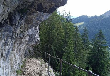
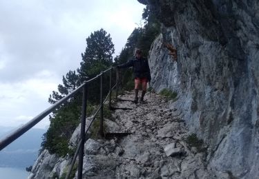
ATTENTION, pour la suite du parcours en crête après le sommet , les 2 ou 3 passages délicats et un peu exposés (pointillés sur la carte IGN) ne sont plus équipés de cordes comme annoncé, et ce depuis cette année 2022 (il reste quelques mousquetons) ; de ce fait des randonneurs renoncent à passer, surtout si le terrain est humide . Par ailleurs, le marquage jaune est très rare dans cette partie. Prévoir une corde en espérant le retour de câbles l'an prochain !
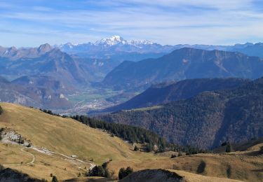
Très beau panorama au sommet et en plusieurs points de la crête notamment au belvédère des "7 deux mille"
A l'extrémité nord du circuit, la redescente vers la piste forestière, bien tracée en lacets au début, se poursuite par une piste raide et glissante par temps humide.
Positioning
Comments
Trails nearby
![Trail Walking Jarsy - BAUGES: PRECHEREL - CROIX D'ALLANT - PLAN DE LA LIMACE - en direction du Mont de la Coche - Photo](https://media.geolcdn.com/t/375/260/a1c1a220-f26a-4fbe-a6ad-eda1f1982f07.jpg&format=jpg&maxdim=2)
![Walking Walking](https://static1.geolcdn.com/sitytour/trail-icons/101.png)
Walking
![](/images/other/stat-length.png)
![](https://static1.geolcdn.com/siteimages/upload/files/16400158638029165_repeat_loop_refresh_sync_direction_icon.png)
![Trail Walking Doucy-en-Bauges - Traversée du Mont Trélod, 2181m - Photo](https://media.geolcdn.com/t/375/260/ext.jpg?maxdim=2&url=https%3A%2F%2Fservices.sitytrail.com%2FGeolivesWS%2FDownloadMedia.ashx%3FTrailID%3D103833%26Media%3D6623_1.jpg)
![Walking Walking](https://static1.geolcdn.com/sitytour/trail-icons/101.png)
Walking
![](/images/other/stat-length.png)
![](https://static1.geolcdn.com/siteimages/upload/files/16400158638029165_repeat_loop_refresh_sync_direction_icon.png)
![Trail Walking Bellecombe-en-Bauges - Pointe de Banc Plat en boucle - Photo](https://media.geolcdn.com/t/375/260/80b75f38-16b0-40b8-9a99-ebc551fd27ff.jpg&format=jpg&maxdim=2)
![Walking Walking](https://static1.geolcdn.com/sitytour/trail-icons/101.png)
Walking
![](/images/other/stat-length.png)
![](https://static1.geolcdn.com/siteimages/upload/files/16400158638029165_repeat_loop_refresh_sync_direction_icon.png)
![Trail Touring skiing Bellecombe-en-Bauges - la dent des portes et sous le Trelod - Photo](https://media.geolcdn.com/t/375/260/5df2df97-f7db-4fea-9d78-8be71e3fb466.jpg&format=jpg&maxdim=2)
![Touring skiing Touring skiing](https://static1.geolcdn.com/sitytour/trail-icons/503.png)
Touring skiing
![](/images/other/stat-length.png)
![](https://static1.geolcdn.com/siteimages/upload/files/16400158638029165_repeat_loop_refresh_sync_direction_icon.png)
![Trail Touring skiing Le Châtelard - col de Rossanaz - Photo](https://media.geolcdn.com/t/375/260/50e32d24-befc-4efc-87ab-b6a2311f6d3b.jpg&format=jpg&maxdim=2)
![Touring skiing Touring skiing](https://static1.geolcdn.com/sitytour/trail-icons/503.png)
Touring skiing
![](/images/other/stat-length.png)
![](https://static1.geolcdn.com/siteimages/upload/files/16400158638029165_repeat_loop_refresh_sync_direction_icon.png)
![Trail Walking Le Châtelard - Roc poyet - Photo](https://media.geolcdn.com/t/375/260/a503fd55-09ac-42bc-9003-547472a05706.jpg&format=jpg&maxdim=2)
![Walking Walking](https://static1.geolcdn.com/sitytour/trail-icons/101.png)
Walking
![](/images/other/stat-length.png)
![](https://static1.geolcdn.com/siteimages/upload/files/16400158638029165_repeat_loop_refresh_sync_direction_icon.png)
![Trail Walking Bellecombe-en-Bauges - Banc plat boucle - Photo](https://media.geolcdn.com/t/375/260/a2db89fd-d92b-448f-a4ef-41a90ffed31c.jpg&format=jpg&maxdim=2)
![Walking Walking](https://static1.geolcdn.com/sitytour/trail-icons/101.png)
Walking
![](/images/other/stat-length.png)
![](https://static1.geolcdn.com/siteimages/upload/files/16400158638029165_repeat_loop_refresh_sync_direction_icon.png)
![Trail Walking Doucy-en-Bauges - 2015-09-11 Marche Mont Trelod - Photo](https://media.geolcdn.com/t/375/260/ext.jpg?maxdim=2&url=https%3A%2F%2Fstatic1.geolcdn.com%2Fsiteimages%2Fupload%2Ffiles%2F1553511878bg_sport_marche.png)
![Walking Walking](https://static1.geolcdn.com/sitytour/trail-icons/101.png)
Walking
![](/images/other/stat-length.png)
![](https://static1.geolcdn.com/siteimages/upload/files/16400158638029165_repeat_loop_refresh_sync_direction_icon.png)
![Trail Walking Bellecombe-en-Bauges - BAUGES: BANC PLAT via REPOSOIR - BORNETTE - REFUGE COMBE - Photo](https://media.geolcdn.com/t/375/260/e352fcdc-17f0-46fd-b7a7-5ac4f4bb5365.jpg&format=jpg&maxdim=2)
![Walking Walking](https://static1.geolcdn.com/sitytour/trail-icons/101.png)
Walking
![](/images/other/stat-length.png)
![](https://static1.geolcdn.com/siteimages/upload/files/16400158638029165_repeat_loop_refresh_sync_direction_icon.png)